WHAT IS "LAKSHADWEEP"?
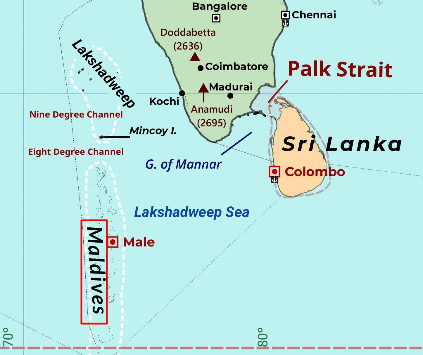
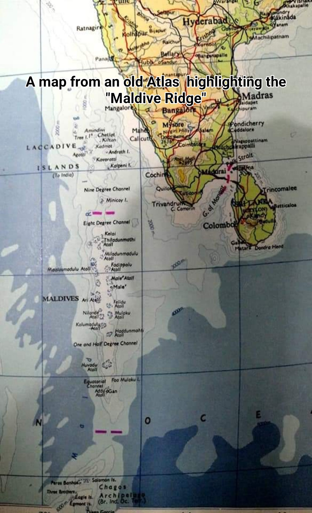
Lakshadweep is a Union Territory of India located in the "Arabian Sea" to the west of the Indian mainland and north of the Maldives. It is part of the "Maldive Ridge" or "Laccadive-Chagos Ridge" (Lakshadweep-Chagos Ridge), which includes the atolls of the Maldives and Chagos Archipelago. These atolls are the northernmost of the underwater ridge, spread over an area of 20,000 square kilometers, starting from 70 miles north of the Maldives. Minicoy, which was historically part of the Maldives, is also a part of Lakshadweep. Minicoy is the closest Lakshadweep island to the Maldives.
Including Minicoy, Lakshadweep has 12 atolls. Additionally, there are three separate reefs and five submerged banks. Unlike the Maldivian atolls, Lakshadweep's atolls are very small. They resemble the reefs or "faros" found within larger Maldivian atolls. For example, they are similar to Kelaa, Filladhoo, or Maafaru in the Maldives. There aren't many islands within each atoll. The total lagoon area of the atolls and reefs is 4,200 square kilometers. Lakshadweep has a total of 39 islands, including 10 inhabited islands. Apart from the 10 inhabited islands, the rest are generally very small. The total land area of Lakshadweep is 32 square kilometers. However, because the Lakshadweep atolls are spread out, the territorial waters cover an area of 20,000 square kilometers. The Exclusive Economic Zone extends to 400,000 square kilometers.
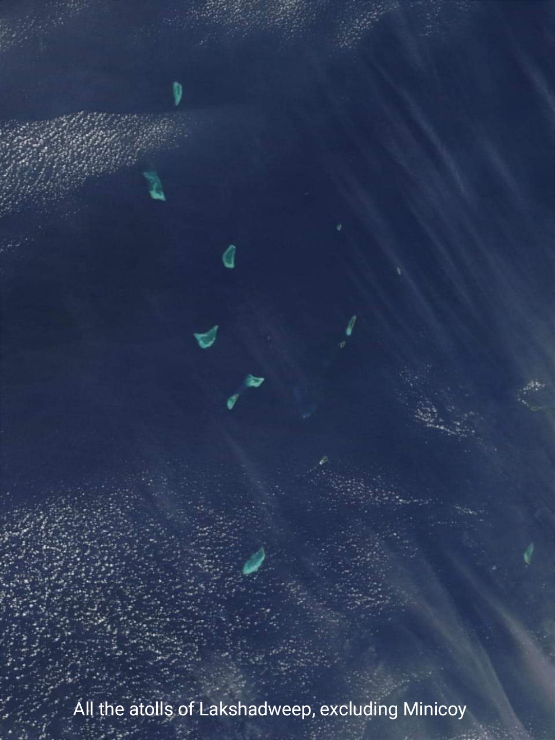
Throughout history, there is no evidence that modern Lakshadweep has ever existed as an independent nation with its own government. Except for Minicoy, the ethnicity, dialect, and culture of the people living there are connected to the Malabar region, which is the nearest mainland region. Minicoy was a part of the Maldives until 1752 CE. Even before that, Minicoy had come under Malabar rule. However, the ethnicity, dialect, and culture of its inhabitants are connected to the Maldives. The entire population of Lakshadweep is Muslim. After being under the control of various South Indian rulers, these islands came under the British, who were colonizing different countries and states in the Indian subcontinent. Under British rule, the official name for these islands was Laccadive, Minicoy, and Amindivi Islands. Here, 'Minicoy' is a corrupted form of the name Maliku. When British India gained independence as two separate nations in 1947, the Laccadive, Minicoy, and Amindivi Islands became part of the Dominion of India. At that time, these islands were part of the Malabar District of Madras Presidency. However, on November 1, 1956, when India's states and territories were reorganized, it became a separate "Union Territory" unconnected to any state. The name of this Union Territory was changed from Laccadive, Minicoy, and Amindivi Islands to Lakshadweep on November 1, 1973. In earlier English writings, these islands were also referred to as the Laccadive Islands.
WHAT IS THE ORIGIN OF THE NAME 'LAKSHADWEEP'?
Lakshadweep is formed by combining 'Laksha' and 'dweep'. These two words have their origins in Sanskrit. Laksha means one hundred thousand, and dweep means island. Therefore, Lakshadweep means one hundred thousand islands. This is also the meaning in Malayalam or Jasseri dialect spoken in the islands of Lakshadweep, except for Minicoy. However, as mentioned earlier, the total number of these islands is only 39. So how did it come to be called one hundred thousand islands?
Even if it doesn't reach one hundred thousand, the term 'laksha' might be used to indicate a large number of islands. In Dhivehi language too, 'lakka' is sometimes used to mean 'many'. However, considering the number of islands in Lakshadweep, it can't really be said to be that many. If we include the islands of Maldives and Chagos, then it could be called that way. In fact, it has been referred to as such in the past.
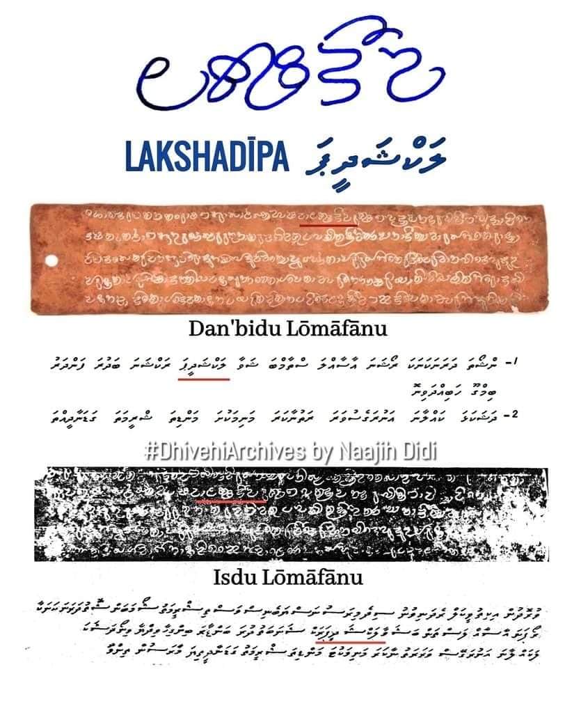
In the Isdhoo and Dhanbidhoo Loamaafaanu (copper plate grants) written in the Maldives during the 12th century CE, the Maldives is referred to as "Lakshadeepa". When these two Loamaafaanu were translated into English and Dhivehi, it was translated as 'one hundred thousand islands'. It wasn't written in a way that suggested it was a proper name. In any case, whether to indicate the abundance of islands or not, that name was used in reference to the Maldives. This was in an official Maldivian document written in old Eveylaa script of Dhivehi. However, in later times, the common Dhivehi name has been Dhivehi Raajje, or the Island Kingdom.
MALDIVES
The Maldives is located in the Indian Ocean, south of Lakshadweep, between the Chagos Archipelago and Lakshadweep. Spread over an area of approximately 870 kilometers, the Maldives is the largest and most numerous of the atoll islands formed on the underwater ridge known as the "Maldive Ridge" or "Laccadive-Chagos Ridge". Consisting of 26 atolls or natural divisions, the Maldives' reefs and lagoons are many times larger than those of Lakshadweep. The Maldivian territorial waters cover an area of 41,490 square kilometers. And the Exclusive Economic Zone extends to 859,000 square kilometers. Of the approximately 1,200 islands in the Maldives, 186 are inhabited. The land area of the islands is approximately 300 square kilometers. The Maldives is also the most populous of the two island groups.
Unlike Lakshadweep, the Maldives has been an independent nation with its own government since ancient times. Throughout history, the Maldivian self-governance has rarely been interrupted. Even when the British ruled the Indian subcontinent and Ceylon, the Maldives was governed by Maldivians. By Maldivian kings and Maldivian ministers. Doesn't the name "Dhivehi Raajje" itself imply this? As mentioned earlier, it means the Island Kingdom.
WHAT IS THE 'LAKSHADWEEP SEA'? AND WHEN DID THIS NAME COME INTO USE?
The sea appearing as 'Lakshadweep Sea' on modern maps is a very recent term in maritime geography. This name began to be used as 'Laccadive Sea'. I first learned of this name in 1993 when I was in 8th grade at Majeediyya School, during a geography exam where we had to mark the Laccadive Sea on a map of the Maldives. Even then, I didn't believe there should be a sea called Laccadive Sea on the Maldives map. However, since it was an exam, I wrote 'Laccadive Sea' in very small letters in a corner of the map. In any case, the Laccadive Sea came into existence and its name entered the documents of the International Hydrographic Organization, the special organization for world seas, in 1953. The sea and its boundaries were defined and written in the third edition of 'Limits of Oceans and Seas' published by the organization after India gained independence. In the two editions published before India's independence, there was no mention of a Laccadive Sea.
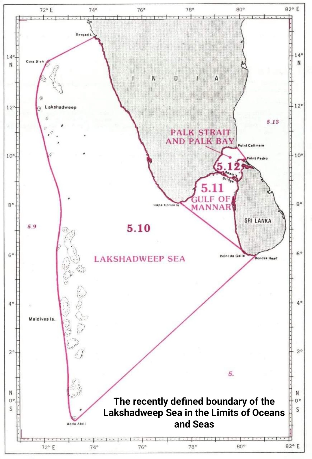
According to the 'Limits of Oceans and Seas' published in 1953, the Laccadive Sea is defined as the sea extending from a line drawn from Sadashivgad, a town on the coast of Karnataka State in India, to the Cora Divh shoal, including the Laccadive (now Lakshadweep) and all islands of the Maldives from the western edge to the southernmost tip of Addu Atoll, stretching all the way to Sri Lanka.
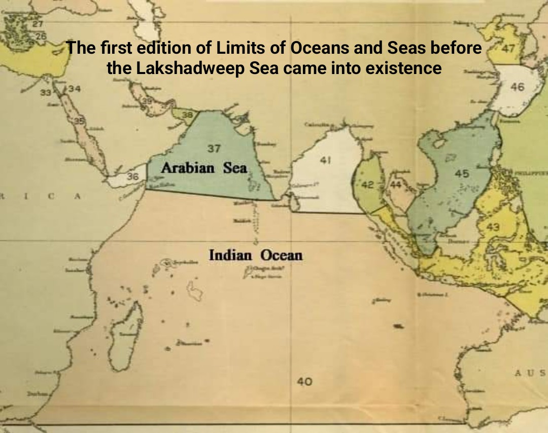
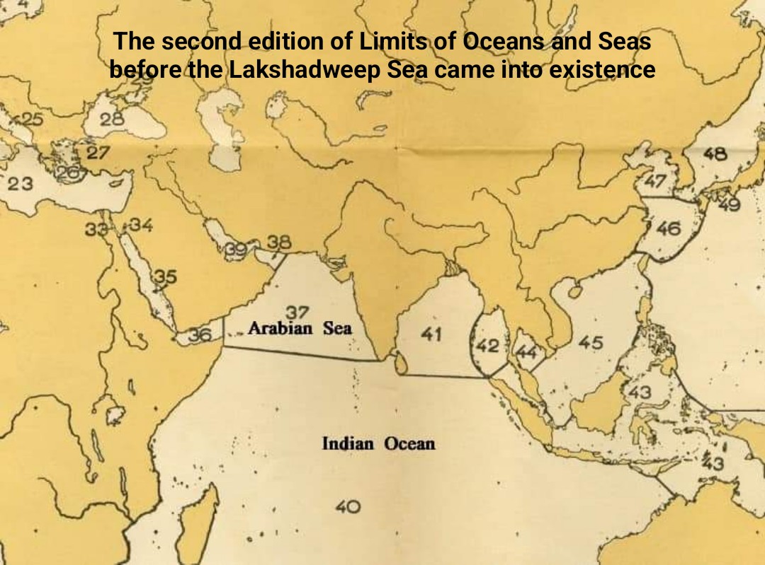
Although it entered the official documents of the International Hydrographic Organization in 1953, the name wasn't very common until quite recently. Even Indian writers writing about the Lakshadweep islands used to write that Lakshadweep is located in the Arabian Sea until recently. This is because that was the commonly used name. In the first edition of 'Limits of Oceans and Seas' published in 1928, an, and in its second edition published in 1937, the sea up to Minicoy, the southernmost island of Lakshadweep, was named the Arabian Sea. The area including the Maldives was called the Indian Ocean. This means that the Laccadive Sea had not yet come into existence then. The Laccadive Sea became the Lakshadweep Sea since India changed the name of Laccadive, Minicoy and Amindivi Islands to Lakshadweep. This confirms that this name is directly given by India in reference to its Union Territory.
CONCLUSION
We have always been saying that the Maldives is located in the Indian Ocean. Even in our national songs, we say that Maldives is in the Indian Ocean. The famous song goes: "Hindhu e maa kan'du therey, ali ran muiyhen dhirey, mee magey ufan bimey, dheebu dhivehi mee." It means: "It's the Maldivian archipelago that shines like a bright pearl in the Indian Ocean." We do not object to the ocean where the Maldives is located being named after the historic Indian subcontinent (which includes the present-day India, Pakistan, and Bangladesh). However, it is somewhat difficult to accept that the sea where the Maldives is located is named after a much smaller territory and a union territory of another nation. Nevertheless, even if you open Google Maps today, you can see that name up to Addu Atoll. Even if we can't make a big change to that, we can write our texts the way we want. And we don't necessarily have to call this sea the "Maldives Sea". We don't claim that either. However, if we were to give a specific name to the sea that includes Lakshadweep and the Maldives, it is certain that "Maldives Sea" would be most appropriate. In older maps, you can even see the underwater ridge that includes Lakshadweep, Maldives, and Chagos labeled as "Maldive Ridge". However, now it appears as "Lakshadweep-Chagos Ridge". That name has also been changed, possibly due to the same influence.
Lakshadweep is a Union Territory of India located in the "Arabian Sea" to the west of the Indian mainland and north of the Maldives. It is part of the "Maldive Ridge" or "Laccadive-Chagos Ridge" (Lakshadweep-Chagos Ridge), which includes the atolls of the Maldives and Chagos Archipelago. These atolls are the northernmost of the underwater ridge, spread over an area of 20,000 square kilometers, starting from 70 miles north of the Maldives. Minicoy, which was historically part of the Maldives, is also a part of Lakshadweep. Minicoy is the closest Lakshadweep island to the Maldives.
Including Minicoy, Lakshadweep has 12 atolls. Additionally, there are three separate reefs and five submerged banks. Unlike the Maldivian atolls, Lakshadweep's atolls are very small. They resemble the reefs or "faros" found within larger Maldivian atolls. For example, they are similar to Kelaa, Filladhoo, or Maafaru in the Maldives. There aren't many islands within each atoll. The total lagoon area of the atolls and reefs is 4,200 square kilometers. Lakshadweep has a total of 39 islands, including 10 inhabited islands. Apart from the 10 inhabited islands, the rest are generally very small. The total land area of Lakshadweep is 32 square kilometers. However, because the Lakshadweep atolls are spread out, the territorial waters cover an area of 20,000 square kilometers. The Exclusive Economic Zone extends to 400,000 square kilometers.

Throughout history, there is no evidence that modern Lakshadweep has ever existed as an independent nation with its own government. Except for Minicoy, the ethnicity, dialect, and culture of the people living there are connected to the Malabar region, which is the nearest mainland region. Minicoy was a part of the Maldives until 1752 CE. Even before that, Minicoy had come under Malabar rule. However, the ethnicity, dialect, and culture of its inhabitants are connected to the Maldives. The entire population of Lakshadweep is Muslim. After being under the control of various South Indian rulers, these islands came under the British, who were colonizing different countries and states in the Indian subcontinent. Under British rule, the official name for these islands was Laccadive, Minicoy, and Amindivi Islands. Here, 'Minicoy' is a corrupted form of the name Maliku. When British India gained independence as two separate nations in 1947, the Laccadive, Minicoy, and Amindivi Islands became part of the Dominion of India. At that time, these islands were part of the Malabar District of Madras Presidency. However, on November 1, 1956, when India's states and territories were reorganized, it became a separate "Union Territory" unconnected to any state. The name of this Union Territory was changed from Laccadive, Minicoy, and Amindivi Islands to Lakshadweep on November 1, 1973. In earlier English writings, these islands were also referred to as the Laccadive Islands.
WHAT IS THE ORIGIN OF THE NAME 'LAKSHADWEEP'?
Lakshadweep is formed by combining 'Laksha' and 'dweep'. These two words have their origins in Sanskrit. Laksha means one hundred thousand, and dweep means island. Therefore, Lakshadweep means one hundred thousand islands. This is also the meaning in Malayalam or Jasseri dialect spoken in the islands of Lakshadweep, except for Minicoy. However, as mentioned earlier, the total number of these islands is only 39. So how did it come to be called one hundred thousand islands?
Even if it doesn't reach one hundred thousand, the term 'laksha' might be used to indicate a large number of islands. In Dhivehi language too, 'lakka' is sometimes used to mean 'many'. However, considering the number of islands in Lakshadweep, it can't really be said to be that many. If we include the islands of Maldives and Chagos, then it could be called that way. In fact, it has been referred to as such in the past.
In the Isdhoo and Dhanbidhoo Loamaafaanu (copper plate grants) written in the Maldives during the 12th century CE, the Maldives is referred to as "Lakshadeepa". When these two Loamaafaanu were translated into English and Dhivehi, it was translated as 'one hundred thousand islands'. It wasn't written in a way that suggested it was a proper name. In any case, whether to indicate the abundance of islands or not, that name was used in reference to the Maldives. This was in an official Maldivian document written in old Eveylaa script of Dhivehi. However, in later times, the common Dhivehi name has been Dhivehi Raajje, or the Island Kingdom.

MALDIVES
The Maldives is located in the Indian Ocean, south of Lakshadweep, between the Chagos Archipelago and Lakshadweep. Spread over an area of approximately 870 kilometers, the Maldives is the largest and most numerous of the atoll islands formed on the underwater ridge known as the "Maldive Ridge" or "Laccadive-Chagos Ridge". Consisting of 26 atolls or natural divisions, the Maldives' reefs and lagoons are many times larger than those of Lakshadweep. The Maldivian territorial waters cover an area of 41,490 square kilometers. And the Exclusive Economic Zone extends to 859,000 square kilometers. Of the approximately 1,200 islands in the Maldives, 186 are inhabited. The land area of the islands is approximately 300 square kilometers. The Maldives is also the most populous of the two island groups.
Unlike Lakshadweep, the Maldives has been an independent nation with its own government since ancient times. Throughout history, the Maldivian self-governance has rarely been interrupted. Even when the British ruled the Indian subcontinent and Ceylon, the Maldives was governed by Maldivians. By Maldivian kings and Maldivian ministers. Doesn't the name "Dhivehi Raajje" itself imply this? As mentioned earlier, it means the Island Kingdom.

WHAT IS THE 'LAKSHADWEEP SEA'? AND WHEN DID THIS NAME COME INTO USE?
The sea appearing as 'Lakshadweep Sea' on modern maps is a very recent term in maritime geography. This name began to be used as 'Laccadive Sea'. I first learned of this name in 1993 when I was in 8th grade at Majeediyya School, during a geography exam where we had to mark the Laccadive Sea on a map of the Maldives. Even then, I didn't believe there should be a sea called Laccadive Sea on the Maldives map. However, since it was an exam, I wrote 'Laccadive Sea' in very small letters in a corner of the map. In any case, the Laccadive Sea came into existence and its name entered the documents of the International Hydrographic Organization, the special organization for world seas, in 1953. The sea and its boundaries were defined and written in the third edition of 'Limits of Oceans and Seas' published by the organization after India gained independence. In the two editions published before India's independence, there was no mention of a Laccadive Sea.

According to the 'Limits of Oceans and Seas' published in 1953, the Laccadive Sea is defined as the sea extending from a line drawn from Sadashivgad, a town on the coast of Karnataka State in India, to the Cora Divh shoal, including the Laccadive (now Lakshadweep) and all islands of the Maldives from the western edge to the southernmost tip of Addu Atoll, stretching all the way to Sri Lanka.

Although it entered the official documents of the International Hydrographic Organization in 1953, the name wasn't very common until quite recently. Even Indian writers writing about the Lakshadweep islands used to write that Lakshadweep is located in the Arabian Sea until recently. This is because that was the commonly used name. In the first edition of 'Limits of Oceans and Seas' published in 1928, an, and in its second edition published in 1937, the sea up to Minicoy, the southernmost island of Lakshadweep, was named the Arabian Sea. The area including the Maldives was called the Indian Ocean. This means that the Laccadive Sea had not yet come into existence then. The Laccadive Sea became the Lakshadweep Sea since India changed the name of Laccadive, Minicoy and Amindivi Islands to Lakshadweep. This confirms that this name is directly given by India in reference to its Union Territory.

CONCLUSION
We have always been saying that the Maldives is located in the Indian Ocean. Even in our national songs, we say that Maldives is in the Indian Ocean. The famous song goes: "Hindhu e maa kan'du therey, ali ran muiyhen dhirey, mee magey ufan bimey, dheebu dhivehi mee." It means: "It's the Maldivian archipelago that shines like a bright pearl in the Indian Ocean." We do not object to the ocean where the Maldives is located being named after the historic Indian subcontinent (which includes the present-day India, Pakistan, and Bangladesh). However, it is somewhat difficult to accept that the sea where the Maldives is located is named after a much smaller territory and a union territory of another nation. Nevertheless, even if you open Google Maps today, you can see that name up to Addu Atoll. Even if we can't make a big change to that, we can write our texts the way we want. And we don't necessarily have to call this sea the "Maldives Sea". We don't claim that either. However, if we were to give a specific name to the sea that includes Lakshadweep and the Maldives, it is certain that "Maldives Sea" would be most appropriate. In older maps, you can even see the underwater ridge that includes Lakshadweep, Maldives, and Chagos labeled as "Maldive Ridge". However, now it appears as "Lakshadweep-Chagos Ridge". That name has also been changed, possibly due to the same influence.


